History of Saint Barthelemy
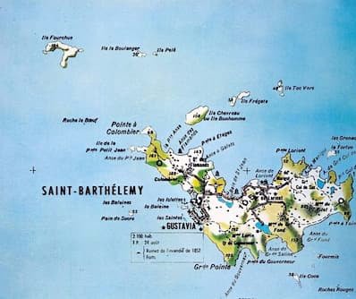
The island of Saint-Barthélemy (also called Saint-Barth or St.Barts in Creole) is part of the Leeward Islands in the Lesser Antilles. It covers an area of 21 km² and is located between Sint Maarten/St Martin Island and the islands of St Kitts and Nevis (St Kitts and Nevis) in the southwest and Barbados Island in the southeast.
Saint-Barthélemy is 25 km east of Saint-Martin, another French island in the West Indies, and 200 km northwest of Guadeloupe.Saint-Barth is an archipelago, since it has several islets: Île Chevreau, Île Coco, Île Fourchue, Île Frégate, Île de La Tortue, Île Le Boulanger, Les Grenadins, Pain-de-Sucre, Île Pelée, Île Petit-Jean, Île Toc Vers. The main island, Saint-Barthélemy, is about 10 km long and 2 km wide.The main city of the island is Gustavia, the capital. Other important localities are Saint-Jean, Lorient and Colombier.
The island's dominant activity is luxury tourism, which is based on hotel infrastructures adapted to a clientele that is in principle wealthy.As of 15 July 2007, the status of Saint-Barthélemy was amended. Whereas the island of Saint-Barthélemy was until then a sub-prefecture and the 23rd commune of the overseas department of Guadeloupe (DOM) - the island being part of the arrondissement des îles du Nord - it has become an overseas collectivity (COM).